Where Starlink reports satellite internet
Starlink reports service at 115,411,631 homes and businesses in 51 states (DC included), 99.7% of all locations in the US, as of June 30, 2026.1
Source: FCC, National Broadband Map, data as of June 30, 2026; Census Bureau, Cartographic boundary file cb_2025_us_state_20m. Share of broadband serviceable locations in each state where Starlink reports service of any technology and speed, as of June 30, 2026. Hatched: none reported.
Show the numbers
| State | Share of locations |
|---|---|
| Alabama | 100.0% |
| Alaska | 100.0% |
| Connecticut | 100.0% |
| Georgia | 100.0% |
| Idaho | 100.0% |
| Maine | 100.0% |
| Mississippi | 100.0% |
| Montana | 100.0% |
| Nevada | 100.0% |
| New Jersey | 100.0% |
| New York | 100.0% |
| Rhode Island | 100.0% |
| South Carolina | 100.0% |
| South Dakota | 100.0% |
| Utah | 100.0% |
| Wyoming | 100.0% |
| Arizona | 100.0% |
| Arkansas | 100.0% |
| Colorado | 100.0% |
| Florida | 100.0% |
| Illinois | 100.0% |
| Indiana | 100.0% |
| Kansas | 100.0% |
| Kentucky | 100.0% |
| Louisiana | 100.0% |
| Minnesota | 100.0% |
| Nebraska | 100.0% |
| North Carolina | 100.0% |
| North Dakota | 100.0% |
| Ohio | 100.0% |
| Oregon | 100.0% |
| Tennessee | 100.0% |
| Texas | 100.0% |
| Wisconsin | 100.0% |
| Delaware | 100.0% |
| Missouri | 100.0% |
| Oklahoma | 100.0% |
| Hawaii | 100.0% |
| Michigan | 100.0% |
| Washington | 100.0% |
| California | 100.0% |
| Vermont | 100.0% |
| Virginia | 100.0% |
| District of Columbia | 99.9% |
| West Virginia | 99.7% |
| New Mexico | 99.7% |
| Iowa | 99.2% |
| Massachusetts | 99.2% |
| New Hampshire | 99.0% |
| Maryland | 95.6% |
| Pennsylvania | 95.1% |
Starlink reports satellite home internet at 115.4 million homes and businesses in all 50 states and DC, 99.7% of US locations, as of June 30, 2026. A footprint that covers almost every address says little on its own. The FCC filings are more telling about two narrower things: Starlink is the only satellite service reported at 100/20 Mbps, and at 963,0001 locations satellite is the only home internet anyone reports.
Is Starlink available where you live?
Almost certainly, on paper. Starlink's filing for June 30, 2026 lists 115,411,631 broadband serviceable locations, the FCC's term for each house, apartment building and small business that could get service. That is 99.7% of the 115,784,915 locations on the FCC's list (revision of November 10, 2026). In Texas alone it reports 10,398,145 locations, 100.0%1 of the state's total.
"Available" has a specific meaning here. A provider lists a location when it says it could connect it within ten business days with a standard installation. The filing is Starlink's own claim, and anyone can challenge it on the FCC National Broadband Map, which also shows what each provider reports at a single address.
The gaps are concentrated in two states. Starlink reports 95.1% of Pennsylvania's locations and 95.6% of Maryland's, while New Hampshire (99.0%), Massachusetts (99.2%) and Iowa (99.2%) fall just short of full coverage. The cities do not explain it: Philadelphia (100.0%), Pittsburgh (100.0%) and Baltimore (100.0%1) are fully listed, so the unlisted locations lie elsewhere in those states.
The one satellite service filed at 100/20
Three companies report satellite home internet across nearly the whole country, and two of their footprints are almost identical in size: HughesNet at 115.5 million locations and Starlink at 115.4 million; Viasat, at 95.3 million, files much of the East Coast for business customers only. What separates them in the data is speed. Starlink reports a maximum advertised speed of at least 100 Mbps download and 20 Mbps upload at all 115,411,631 of its locations. HughesNet reports that tier at 0 locations and Viasat at 01.
The FCC files satellite service under two technology codes, 60 for geostationary satellites and 61 for low-Earth-orbit satellites such as Starlink, as our methodology explains. All of these speeds are advertised maximums from the filings.
Two limits apply. First, 100/20 from a satellite does not make a location "served" under the federal BEAD program's definitions, which count only fiber, cable, DSL and licensed fixed wireless as reliable service (see the methodology). Second, because every satellite provider reports nearly everywhere, this site leaves satellite out of its "can get broadband" headlines and shows where it is the only option instead.
Where satellite is the only option
At 962,554 locations, 0.8%1 of the national total, no fiber, cable, DSL or fixed wireless provider reports any service; satellite is all the FCC data list. For these homes and businesses, the satellite filings are the whole of what the FCC data offer, and among them only Starlink's is reported at 100/20 Mbps.
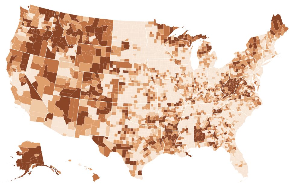
Source: FCC, National Broadband Map, data as of June 30, 2026; Census Bureau, Cartographic boundary file cb_2025_us_county_5m. FCC file revision of November 10, 2026. Shares are of broadband serviceable locations (homes and businesses), not people. The table lists the 25 highest and 25 lowest counties; every county is in the downloads.
Show the numbers
| County | Satellite only |
|---|---|
| Yakutat City and Borough, Alaska | 100.0% |
| Kalawao County, Hawaii | 56.6% |
| Wheeler County, Oregon | 44.9% |
| Southeast Fairbanks Census Area, Alaska | 41.9% |
| Carter County, Missouri | 40.3% |
| Garfield County, Montana | 36.8% |
| Keweenaw County, Michigan | 35.6% |
| Yukon-Koyukuk Census Area, Alaska | 35.1% |
| Calhoun County, West Virginia | 34.8% |
| Catron County, New Mexico | 34.6% |
| Alpine County, California | 34.0% |
| Boise County, Idaho | 33.9% |
| Rappahannock County, Virginia | 33.5% |
| Perry County, Alabama | 33.2% |
| Sumter County, Alabama | 32.6% |
| Petroleum County, Montana | 32.6% |
| Lake and Peninsula Borough, Alaska | 32.0% |
| Sioux County, Nebraska | 31.4% |
| Braxton County, West Virginia | 31.4% |
| Forest County, Pennsylvania | 30.4% |
| Prince of Wales-Hyder Census Area, Alaska | 28.5% |
| East Feliciana Parish, Louisiana | 27.7% |
| Trinity County, California | 27.6% |
| St. Helena Parish, Louisiana | 27.5% |
| Graham County, North Carolina | 26.9% |
| Bailey County, Texas | 0.0% |
| Glasscock County, Texas | 0.0% |
| Hardeman County, Texas | 0.0% |
| Lynn County, Texas | 0.0% |
| Parmer County, Texas | 0.0% |
| Terry County, Texas | 0.0% |
| Wichita County, Texas | 0.0% |
| Alexandria city, Virginia | 0.0% |
| Bristol city, Virginia | 0.0% |
| Emporia city, Virginia | 0.0% |
| Fairfax city, Virginia | 0.0% |
| Falls Church city, Virginia | 0.0% |
| Lexington city, Virginia | 0.0% |
| Manassas city, Virginia | 0.0% |
| Norton city, Virginia | 0.0% |
| Winchester city, Virginia | 0.0% |
| Marion County, Alabama | 0.0% |
| Greene County, Arkansas | 0.0% |
| Sacramento County, California | 0.0% |
| San Francisco County, California | 0.0% |
| Sutter County, California | 0.0% |
| Broomfield County, Colorado | 0.0% |
| Denver County, Colorado | 0.0% |
| Phillips County, Colorado | 0.0% |
| Greater Bridgeport Planning Region, Connecticut | 0.0% |
The pattern is far from even. Alaska's share, 7.2% of its locations, is the highest among the states, and in Yakutat City and Borough the figure is 100.0%. West Virginia follows at 6.4%, then Wyoming (3.8%) and Montana (3.5%). Outside Alaska, the highest county shares include Kalawao County, Hawaii (56.6%), Wheeler County, Oregon (44.9%) and Carter County, Missouri (40.3%). By count, California has the most satellite-only locations, 67,934, ahead of West Virginia's 57,1571.
Source: FCC, National Broadband Map, data as of June 30, 2026. FCC file revision of November 10, 2026. Shares are of broadband serviceable locations (homes and businesses), not people.
Show the numbers
| State | Satellite only |
|---|---|
| Alaska | 7.2% |
| West Virginia | 6.4% |
| Wyoming | 3.8% |
| Montana | 3.5% |
| Idaho | 2.4% |
| Maine | 2.4% |
| Louisiana | 2.3% |
| Alabama | 1.9% |
| Arkansas | 1.8% |
| Virginia | 1.7% |
| Washington | 1.7% |
| Oregon | 1.7% |
| United States | 0.8% |
This gap has not shrunk since the first National Broadband Map. The national share rose from 0.4% in June 2022 to 0.8%, while the share of locations with no terrestrial service at 100/20 fell by 7.3 percentage points. West Virginia's share rose the most of any state: from 2.9%4 to 6.4%, a change of +3.5 percentage points. Since December 2025 the national share has edged down by 0.1 percentage points1.
What the filings show since 2022
Starlink's reported location count grew by 5,795,139 between June 2022 and June 2026, more than HughesNet (+3,479,322) or Viasat (−16,803,1654). Part of every provider's change comes from the FCC's own list, which added +3,495,3291 locations over the same period through new construction and corrections. Starlink's growth exceeds that, so its filing now covers locations it did not list in 2022.
The latest half-year looks different. Starlink added +581,3155 locations since December 31, 2025, almost exactly the +581,0491 the FCC added to its list over the same months. Over the latest six months, then, the growth in Starlink's filing tracks the FCC's list.
Who subscribes to satellite internet
Availability and use are different questions, and the second comes from the Census Bureau's American Community Survey, which counts households, not locations. It asks which kinds of internet subscription a household has; households can name more than one, and the survey does not record the company, so these figures cover Starlink, HughesNet and Viasat together.
Source: Census Bureau, American Community Survey 2025 1-year detailed tables. Whiskers show the 90% margin of error. Period: 2025.
Show the numbers
| State | Households with satellite internet | MOE |
|---|---|---|
| Alaska | 16.0% | ±1.1 |
| Wyoming | 14.1% | ±1.3 |
| Idaho | 12.6% | ±0.6 |
| Montana | 12.2% | ±0.8 |
| New Mexico | 10.1% | ±0.7 |
| West Virginia | 9.5% | ±0.7 |
| Mississippi | 9.4% | ±0.5 |
| Alabama | 8.8% | ±0.4 |
| Arizona | 8.6% | ±0.3 |
| Nevada | 8.5% | ±0.6 |
| Colorado | 8.4% | ±0.4 |
| Louisiana | 8.4% | ±0.4 |
| Missouri | 8.4% | ±0.3 |
| Oklahoma | 8.3% | ±0.3 |
| Iowa | 8.1% | ±0.4 |
In 2025, Alaska's estimate was the highest: 16.0% of households (±1.1 percentage points), followed by Wyoming at 14.1% (±1.3 percentage points), Idaho at 12.6% (±0.6 percentage points) and Montana at 12.2% (±0.8 percentage points). These are largely the same states where satellite-only locations are common. Massachusetts was lowest at 3.4% (±0.2 percentage points6).
The city figures are less tidy. In Hialeah, Florida, 27.7% of households reported satellite internet (±2.9 percentage points), an estimate that was the highest among large cities, in a city where wired 100/20 service is reported at 99.9%1 of locations. In Torrance, California, the estimate was 19.1% (±3.5 percentage points6). The answers are self-reported, and the margins at city level are wide, so the Hialeah and Torrance estimates show what residents said, not which network they use.
Low-Earth-orbit satellite in the BEAD plans
The Broadband Equity, Access, and Deployment program is NTIA's grant program for the remaining unserved and underserved locations. In the final proposals NTIA approved, 829,696 of the 3,772,113 locations in the plans were assigned to low-Earth-orbit satellite, the technology Starlink uses, against 2,368,2387 to fiber. NTIA's state summaries report these totals by technology, not by company, and mark them as subject to final review.
Source: NTIA BroadbandUSA, BEAD Final Proposal Overview one-page PDFs.
Show the numbers
| State | BEAD locations assigned to low-Earth-orbit satellite |
|---|---|
| Montana | 63.7% |
| Colorado | 49.6% |
| South Carolina | 48.7% |
| Ohio | 48.1% |
| Oregon | 46.5% |
| Wyoming | 40.8% |
| South Dakota | 38.3% |
| Massachusetts | 34.8% |
| North Carolina | 34.6% |
| Alaska | 33.9% |
| Nebraska | 33.9% |
| Nevada | 28.2% |
| New York | 28.1% |
| Texas | 27.1% |
| California | 27.0% |
The share varies widely. Montana's satellite share was the highest: 63.7% of its plan, or 43,662 locations, followed by Colorado (49.6%), South Carolina (48.7%) and Ohio (48.1%). Connecticut and Delaware assigned no locations to it (0.0%). In California the satellite share was 27.0%, or 72,9377 locations. Each state page shows its plan's full technology mix.
Every figure on this page is a provider's reported availability or a survey estimate, dated to its release. None of it describes prices or plans; Starlink, like other providers, must publish those on its broadband facts labels.
Starlink state by state
| Texas | 10,398,145 | 100.0% | Satellite | 0 | +615,249 | 280 Mbps |
|---|---|---|---|---|---|---|
| California | 10,285,394 | 100.0% | Satellite | 0 | +304,274 | 280 Mbps |
| Florida | 7,743,565 | 100.0% | Satellite | 0 | +575,950 | 280 Mbps |
| New York | 4,703,116 | 100.0% | Satellite | 0 | +32,787 | 280 Mbps |
| Pennsylvania | 4,644,801 | 95.1% | Satellite | 0 | +28,256 | 280 Mbps |
| Ohio | 4,547,380 | 100.0% | Satellite | 0 | +70,940 | 280 Mbps |
| North Carolina | 4,434,992 | 100.0% | Satellite | 0 | +222,748 | 280 Mbps |
| Illinois | 4,124,582 | 100.0% | Satellite | 0 | −6,778 | 280 Mbps |
| Michigan | 4,007,108 | 100.0% | Satellite | 0 | +308,943 | 280 Mbps |
| Georgia | 3,887,613 | 100.0% | Satellite | 0 | +194,207 | 280 Mbps |
| Virginia | 2,921,808 | 100.0% | Satellite | 0 | +170,776 | 280 Mbps |
| Tennessee | 2,793,238 | 100.0% | Satellite | 0 | +106,911 | 280 Mbps |
| Arizona | 2,787,548 | 100.0% | Satellite | 0 | +215,040 | 280 Mbps |
| Indiana | 2,718,406 | 100.0% | Satellite | 0 | +74 | 280 Mbps |
| New Jersey | 2,587,434 | 100.0% | Satellite | 0 | +52,722 | 280 Mbps |
| Washington | 2,576,896 | 100.0% | Satellite | 0 | +70,929 | 280 Mbps |
| Missouri | 2,518,371 | 100.0% | Satellite | 0 | +31,627 | 280 Mbps |
| Wisconsin | 2,306,213 | 100.0% | Satellite | 0 | +22,596 | 280 Mbps |
| South Carolina | 2,253,518 | 100.0% | Satellite | 0 | +146,098 | 280 Mbps |
| Alabama | 2,206,274 | 100.0% | Satellite | 0 | +66,452 | 280 Mbps |
| Minnesota | 2,127,201 | 100.0% | Satellite | 0 | +47,380 | 280 Mbps |
| Colorado | 1,999,662 | 100.0% | Satellite | 0 | +206,717 | 280 Mbps |
| Massachusetts | 1,950,060 | 99.2% | Satellite | 0 | +219,475 | 280 Mbps |
| Louisiana | 1,868,188 | 100.0% | Satellite | 0 | +12,991 | 280 Mbps |
| Kentucky | 1,843,312 | 100.0% | Satellite | 0 | −41,296 | 280 Mbps |
| Maryland | 1,782,595 | 95.6% | Satellite | 0 | +738,411 | 280 Mbps |
| Oklahoma | 1,741,944 | 100.0% | Satellite | 0 | +55,485 | 280 Mbps |
| Oregon | 1,521,265 | 100.0% | Satellite | 0 | +36,625 | 280 Mbps |
| Arkansas | 1,361,634 | 100.0% | Satellite | 0 | −18,049 | 280 Mbps |
| Iowa | 1,354,407 | 99.2% | Satellite | 0 | −21,559 | 280 Mbps |
| Mississippi | 1,325,923 | 100.0% | Satellite | 0 | +24,594 | 280 Mbps |
| Kansas | 1,193,971 | 100.0% | Satellite | 0 | −7,888 | 280 Mbps |
| Connecticut | 1,092,925 | 100.0% | Satellite | 0 | +16,864 | 280 Mbps |
| Utah | 1,048,011 | 100.0% | Satellite | 0 | +73,865 | 280 Mbps |
| Nevada | 1,027,755 | 100.0% | Satellite | 0 | +71,156 | 280 Mbps |
| West Virginia | 894,931 | 99.7% | Satellite | 0 | +60,990 | 280 Mbps |
| New Mexico | 857,367 | 99.7% | Satellite | 0 | +37,805 | 280 Mbps |
| Nebraska | 794,293 | 100.0% | Satellite | 0 | +99,293 | 280 Mbps |
| Idaho | 773,451 | 100.0% | Satellite | 0 | +61,137 | 280 Mbps |
| Maine | 645,782 | 100.0% | Satellite | 0 | −8,807 | 280 Mbps |
| New Hampshire | 515,608 | 99.0% | Satellite | 0 | +81,520 | 280 Mbps |
| Montana | 498,322 | 100.0% | Satellite | 0 | +99,743 | 280 Mbps |
| Delaware | 410,215 | 100.0% | Satellite | 0 | +24,682 | 280 Mbps |
| South Dakota | 393,489 | 100.0% | Satellite | 0 | +907 | 280 Mbps |
| Rhode Island | 343,860 | 100.0% | Satellite | 0 | +8,194 | 280 Mbps |
| North Dakota | 327,387 | 100.0% | Satellite | 0 | −13,041 | 280 Mbps |
| Hawaii | 320,546 | 100.0% | Satellite | 0 | new | 280 Mbps |
| Alaska | 282,928 | 100.0% | Satellite | 0 | +278,469 | 280 Mbps |
| Vermont | 282,645 | 100.0% | Satellite | 0 | +10,744 | 280 Mbps |
| Wyoming | 262,480 | 100.0% | Satellite | 0 | +2,312 | 280 Mbps |
| District of Columbia | 123,072 | 99.9% | Satellite | 0 | +86,073 | 280 Mbps |
Source: FCC, National Broadband Map, data as of June 30, 2026; FCC, National Broadband Map, data as of June 30, 2022. Broadband serviceable locations where Starlink reports service as of June 30, 2026, compared with June 30, 2022. The FCC location list changes between releases, so part of a change can come from added or corrected locations.
Questions and answers
Is Starlink available in my state?
Starlink reports service in 51 states counting DC. In most of them its filing covers all or nearly all locations; the lowest shares are in Pennsylvania (95.1%) and Maryland (95.6%1). The state table on this page lists every state.
Is Starlink available at my address?
Very probably: Starlink lists 99.7%1 of US locations. Satellite service needs a dish installed at the home, so check the address on the FCC's National Broadband Map, compare what wired and fixed wireless providers report there, and confirm with Starlink.
How fast is Starlink according to the FCC data?
Starlink reports an advertised speed of at least 100/20 Mbps at all 115,411,6311 of its locations. These are maximum advertised speeds from the provider's filing, not measured speeds.
Did Starlink get BEAD funding?
The NTIA summaries of approved BEAD final proposals report locations by technology, not by company. Across them, 829,696 of 3,772,1137 locations were assigned to low-Earth-orbit satellite, the technology Starlink uses.
Is Starlink available at your address?
Area figures cannot answer that. Search the address on the FCC's National Broadband Map, which lists every provider that reports service there, and confirm with Starlink before you sign up. If the map shows Starlink but it cannot connect you within ten business days, you can challenge the listing on the map.
Sources
- FCC, National Broadband Map, data as of June 30, 2026; Availability as of June 30, 2026; released November 10, 2026. broadbandmap.fcc.gov
- Census Bureau, Cartographic boundary file cb_2025_us_state_20m. www2.census.gov
- Census Bureau, Cartographic boundary file cb_2025_us_county_5m. www2.census.gov
- FCC, National Broadband Map, data as of June 30, 2022; Availability as of June 30, 2022; released May 10, 2024. broadbandmap.fcc.gov
- FCC, National Broadband Map, data as of December 31, 2025; Availability as of December 31, 2025; released November 3, 2026. broadbandmap.fcc.gov
- Census Bureau, American Community Survey 2025 1-year detailed tables; 2025 (calendar-year sample); released October 29, 2026. api.census.gov
- NTIA BroadbandUSA, BEAD Final Proposal Overview one-page PDFs. broadbandusa.ntia.gov
Margins of error (±) are at the 90% confidence level. A difference is called significant only when it passes the Census Bureau's test at that level. How every figure is built: methodology. Found an error? Write to [email protected]; corrections are listed on the updates page.